


BRÄMABÜEL
CH-1903 Coordinates: 784.061/183.901
WGS-84 coordinates: N46° 46.850' E9° 50.954'
Altitude: 2485 m.a.s.l.
Usable wind directions: NW-N-NE
Demand: easy
Route description:
In summer, from Jakobshorn via the hiking trail on the north ridge to Brämabüel.
In winter, descend via the north slope and then ascend via the traverse (all machine-groomed) to Brämabüel.
Description:
In summer, start directly north of the station.
In winter, you start northeast of the piste below the windsock. If the wind is too strong from the east, you can start east of the windsock on the ridge.
Alternatives: If the wind on the Bräma is too strong, you can descend in a northerly direction to the Rot-Weiss launch site. The Rot-Weiss launch site is a wonderful place to make an intermediate landing.

RED-WHITE
CH-1903 Coordinates: 783.861/184.426
WGS-84 coordinates: N46° 47.137' E9° 50.809'
Altitude: 2300 m.a.s.l.
Usable wind directions: W-N-NE
Demand: easy
Route: Descend from Brämabüel on the hiking trail in a northerly direction. At the signpost at point 2428, turn west and then leave the path to the north at the first snow gun and follow the ridge to approx. 2300 m above sea level.
Description: The main launch site faces north towards Lake Davos and is equipped with wind indicators. If the wind is blowing more from the west, you can take off flat next to the snow guns towards Schatzalp.

JAKOBSHORN SUMMIT
CH-1903 Coordinates: 783.892/182.984
WGS-84 coordinates: N46° 46.359' E9° 50.799'
Altitude: 2525 m.a.s.l.
Usable wind directions: S-W-NW (N-->difficult)
Demand: easy
Route: Descend from Jakobshorn in a westerly direction to the guardian angel statue.
Description: Start from an easy spot southwest of the statue/spring hut in summer and winter.
Alternatives: If the wind at this launch site is too strong from the south, you can switch to the Jatzhütte launch site.

JATZHÜTTE
CH-1903 Coordinates: 784.237/182.287
WGS-84 coordinates: N46° 45.977' E9° 51.053'
Altitude: 2490 m.a.s.l.
Usable wind directions: SE-S-W
Demand: easy
Route: From Jakobshorn in a south-easterly direction on the road/piste to Jatzhütte.
Description:
In summer, the launch site on the terrace area of the Jatzhütte is only recommended to a limited extent, as there is a lot of scree and steep terrain.
In winter, the launch site on the terrace area next to the chairlift is kept clear of deckchairs. The site is rather small and local pilots appreciate a smooth take-off.
Alternatives: If the wind at this launch site is too strong from the east, you can launch on the northeast side of the hut.
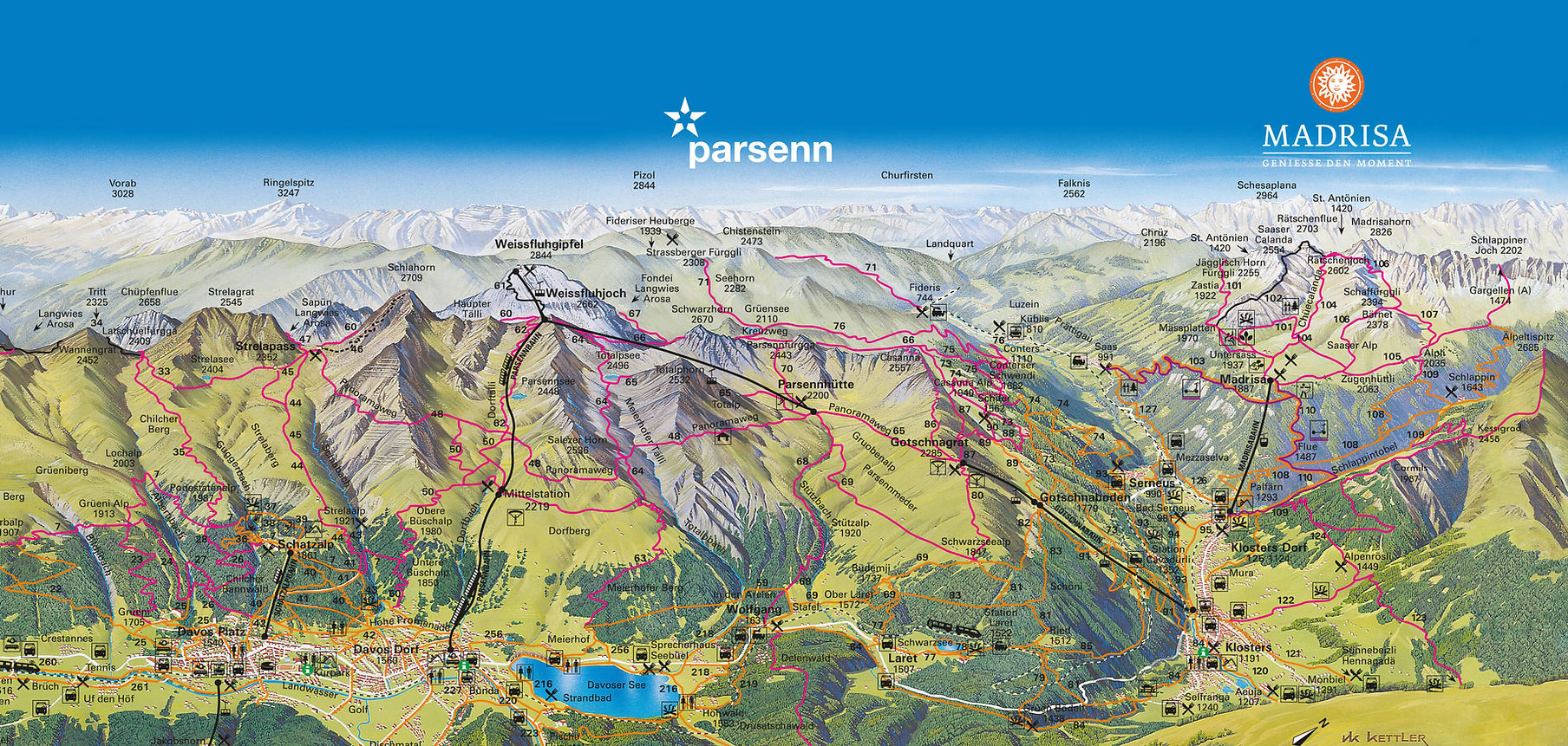

STRELABERG
CH-1903 Coordinates: 781.218/186.808
WGS-84 coordinates: N46° 48.466' E9° 48.790'
Altitude: 2115 m.a.s.l.
Usable wind directions: E-S
Difficulty: easy
Route: Follow the road or the hiking trail towards Strelapass to the chairlift terminus. Ascent approx. 30 minutes. The launch site is located on flat ground at the station between the road and the hiking trail. Description: The launch site is particularly recommended in snow-free periods. If the cross-regional westerly wind is rather weak, a thermal updraft is very likely and can be used for early launches. After noon, a launch is more a matter of luck.
Alternatives: If there is already a downwind at the launch site, there are few alternative launch sites and these involve a longer ascent up to the ridge.

Parsenn high trail
Since 2015, the traditional launch site has been obstructed by avalanche barriers, so it is no longer marked. Nevertheless, there are various launch options, 2 of which are described here. Unfortunately, there is no longer a landing site in Davos Dorf. The Bolgen landing site can only be reached with a good glide ratio and good nerves or some thermals. Beginners are not advised to fly directly to Bolgen without a take-off elevation.
Due to the lack of a landing site, this flying area is particularly recommended for early thermal flights and as a starting point for cross-country flights.
1. CH-1903 coordinates: 781.911/188.250
WGS-84 coordinates: N46° 49.232' E9° 49.369'
Altitude: 2245 m.a.s.l.
Usable wind directions: E-S
Demand: easy
Route description: From the Höhenweg station, ascend 100 meters on the slope north of the 2nd section (30 m). Flat, easy spot with good opportunity to enter the thermal south of the Höhenweg station.
2nd CH-1903 coordinates: 782.142/188.108
WGS-84 coordinates: N46° 49.152' E9° 49.547'
Altitude: 2170 m.a.s.l.
Usable wind directions: E-S
Demand: easy
Route description: From the Höhenweg station, descend in an easterly direction without a path to a flat area, approx. 100 meters of walking and 30 meters of ascent.

Weissfluhjoch
CH-1903 Coordinates: 780.527/189.360
WGS-84 coordinates: N46° 449.854' E9° 48.308'
Altitude: 2625 m.a.s.l.
Usable wind directions: S-E
Demand: medium
Route description: From the Weissfluhjoch descend on the road in the direction of Höhenweg and then cross the chairlift to the southwest under the top 2 masts of the chairlift. The launch site is located on an artificial flattening almost on the ridge.
Description: Alpine launch site on scree. After the artificial edge, the launch site becomes very steep.
Alternatives: If there is still snow below the SLF area, you can take off on the north side of the funicular.
Dangers: Due to the altitude (ridge location) and the direction of take-off, moderate to strong winds from almost all directions are dangerous. The alpine environment makes this even more so.

Salezer Meder
CH-1903 Koordinaten: 782.734/189.219
WGS-84 Koordinaten: N46° 49.741' E9° 50.039'
Höhe: 2200 m.ü.M
Nutzbare Windrichtungen: N-O-S
Anspruch: einfach (Start gegen Norden nur als Klippenstart möglich)
Wegbeschreibung: Von der Station Höhenweg 20 Minuten auf dem Höhenweg Richtung Nordosten, 50 Höhenmeter oberhalb des Höhenwegs.
Beschreibung: Gegen Süden und Osten, flacher einfacher Platz mit guter Möglichkeit zum Thermikeinstieg über dem Maiensäss auf dem Meierhofer Berg. 50 Höhenmeter oberhalb des markierten Startplatzes ist eine grosse Fläche zum Toplanden vorhanden.
Bemerkungen: Potential für frühe Thermik. Das nachmittägliches Soaring im Nordwind bleibt den fortgeschrittenen Piloten vorbehalten, da die Bedingungen für den Start anspruchsvoll und die Flugbedingungen eher turbulent sind.
Dieser Startplatz soll nicht das Morgenfluggebiet 'Höhenweg' ersetzten, sondern die mögliche Nutzungszeit in den Nachmittag mit starkem Talwind hinein erweitern.
Bei diesem Fluggebiet gibt es keinen offiziellen Landeplatz der im Gleitwinkel liegt.

Landing at the foot of the Jakobshorn
In summer, the meadow at Bolgen Plaza in Davos Platz can be used for landing. In winter, you may only land at the Carjöl landing site. It is located next to the cross-country ski trail and behind the Carjöl chairlift. There is a wind marker at the landing site. Landing on the Bolgen area is strictly prohibited in winter.

Landing in Klosters
From Gotschnagrat South and North, you can fly into the valley towards Klosters. The Klosters summer landing site is located near the sports center and the outdoor pool; in winter, you can land at the Klosters winter landing site, east of the sports center and near the Doggilochsee lake.

Gotschnagrat North
The Gotschnabahn mountain station is an excellent starting point for a paragliding flight. From Klosters, the cable car takes you up to the ridge. There is also a weather station there.
Take-off direction: N
Altitude: 2,275 meters above sea level
Gotschnagrat South
Follow the path to the left from the Gotschna cable car mountain station. The starting point is located behind the Schwarzseealp-Gotschnagrat chairlift, which is marked with a wind marker.
Starting direction: S, SW, SE
Altitude: 2,225 meters above sea level